Super User
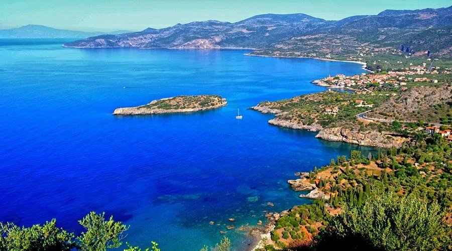
Kardamyli
The gateway to the Mani on the Messinian side is Kardamyli, found 31 km (19 mi) southeast of the market town of Kalamata. It is considered part of the outer Mani, an area less bleak and stark than the inner Mani, which begins at Areopolis. Here the foothills of the Taygettus range are still verdant, and the sun is more forgiving. The quiet and attractive stone town has become a tourist destination for the travelers attracted to its remoteness, stark beauty, and the hiking paths that surround it. Kardamyli's most famous resident was for many years the late Patrick Leigh-Fermor, an Anglo-Irish writer who wrote extensively on Greece and on the Mani in particular. The old section of Kardamyli, northwest of the modern town, is on a pine-scented hillside dotted with small clusters of tower houses, some of which are being restored; stone-paved paths cut through the enclave.
Diros Cave
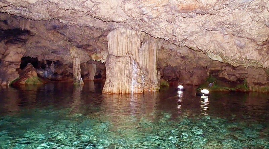
Diros Cave is considered to be the first of the three most beautiful and impressive lake caves in the world (along with this of Padirac in South France and the Jeita Grotto in the capital of Lebanon, Beirut) because of its multicolored and wonderful decoration. It is situated in the south of Areopoli, in Lakonia. The bay of Diros with its white pebbles and the crystal waters lies below the entrance of the cave.
It is consisted by three separate caves: Vlyhada (or Glyphada) which is the only accessible one, Alepotrypa and Katafygi. There is also the Corals' Cave in the vicinity of Diros, where there are stalactites colored ochre, looking like huge corals. These of Alepotrypa and Katafygi settlements are not still accessible, as the explorations inside them are not yet accomplished. The first one at Alepotrypa was discovered in 1958. It is a long cave with large halls and labyrinthine corridors of total length 280 m. At the back of the larger hall there is a lake of clean, drinking water.
The excavating research in the cave started in 1970 by G. Papathanasopoulos and brought under the sun light findings, which prove the human use of the cave during the Neolithic Era (approximately until 3.000 BC). The findings are handy pottery, storage jars, stone and bone tools, loom weights, jewelry and others. Stone paved floors, circular fire places and storage ditches were also spotted. Finally it must be mentioned that plenty of human bone material was revealed mainly at the recesses of the cave but also scattered in it. The conclusion of those is that the cave was continually used as a residence, goods' storage, laboratory of domestic activities and grave place.
The third unit of Diros Cave, the Vlychada Cave, 3,5 km long, is the longest known in Greece. The first part of the cave was discovered by Peter Arapakis in 1898, but the systematic exploration began in 1949 by the couple of John and Ann Petrochelou. Its development started in 1958 and five years later it became accessible to the visitors, with only a ground part of 600m length. 1.600m of length had been explored and mapped until 1960, while the known length of the cave is over 14 km. Its real length has not been verified yet, as the exploration is still conducted over and below the water surface, by cave divers. In 1979 new parts were discovered and ground - laky corridors were mapped. Although, more than 10.000 m2 of archways, chambers and halls have been explored till now, only 3.100 m2 are accessible, from which 300 m2 on ground and the rest on water.
There were residences here during the Neolithic period, according to its findings. Human skeletons and craniums, animal skeletons, tools, marble figurines, pottery and a stone axe were found. It is believed that 45 centuries ago, unlucky residents were enclosed in the cave after a strong earthquake. All findings are exhibited in the Neolithic Museum of Diros.
The flow of the subterranean Glyfada River flows on the bottom of the cave, forming it through this way. This flow lets out at some points, being transformed into lakes. There are too many archways and chambers. The river bed is consisted by limestone which has been modified to marble and develops in two central parallel corridors retaining many bifurcations. There have been made several works for making the cave accessible to visitors. An artificial entrance of 100 m width has been constructed to the left of the natural one, and 1.000m further along the central corridors an artificial tunnel connected them to each other, so the touristic tour traces circular. On the cross point of the water and the ground parts of the cave, bones of a pre-bull and a pre-hippopotamus were found on the bottom. The biggest part of the cave is covered by sea water, so the 45 min of duration tour is conducted on small boats of 8-10 persons.
The main characteristic of the cave is its big and multicoloured stalactites, which have been connected to its bottom, forming palatial columns and also stalactites that look like representing figures of objects, animals or people. The cave began to be formed millions hundreds years ago. The stalactites and the stalagmites lying under the water surface were formed when the sea surface was much lower than today. It is important that stalactites have been found at 71m deep. The maximum water depth is 15,5m and the water temperature is 12°, its hardness on the surface is 90°, in the middle deep 180° and at the bottom 290°. The air temperature in the cave ranges from 16°- 20° in winter and summer.
Brilliant white, pink or red stalactites and stalagmites, sometimes being fuzzy, grey or white columns, formed through the natural rule drop by drop of carbonate calcium, compose the stunning decoration of the cave. The lighted forms are magic and retain names given by the locals, so that the visitors can be helped to comprehend everything. Many of the names come from the Greek mythology, others indicate the ancient Greek lyric tradition which is still preserved by today's Greeks and other names are ought to the historic experiences of the locals. You can enjoy the First Hall with the cloak of Poseidon, the Dead City, the Cross Road with the Nereids and the white Baby Bear, the Lake of Ocean Nymphs with the Stone Forest and the wonderful stalagmite of the Small Haycock.
Subsequently you can see bibelots of unique beauty like the Episcopal Throne, the Foot of Poseidon, the Stone Lily and a Church entrance with a chandelier and the ambo, the Hall of Diros with the ancient Greek chlamys, the Pink and White Departments with the Harp, the Royal Balcony, the Gate and the Hanging Fox and finally the Chapel. Then, an artificial pass leads to the Sea of the Shipwrecks with a sunk ship, the hall of the Golden Rain, the Chocolate Hall, the Red Hall, while in the middle of a canal you can face the Tower of Pisa and at the opposite of it the Crib. Amazed you will be led to the Hall of the Great Ocean with 160m of length and 30m of height with the Large Disk, the innumerable fringes and the Dream Lake, where the river flows into the sea, while the Gothic Hall appears from the next part and the laky route is accomplished. You can step on a path of the next ground part and among the decoration you can observe the Memorial of the Anonymous Seaman, the Palace of Pluto, the Stone Forest and the Nenuphars.
Gerolimenas
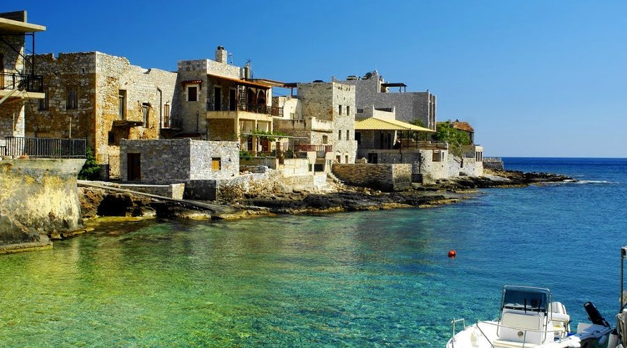
Located at the end of a long natural harbor, around which cluster a few tavernas and shops, Gerolimenas was an important port in the late 19th and early 20th centuries and its name derives from the two Greek words “Ieros” – sacred and “Limin” – port, which give us a thorough idea of just how important it was in the past. Sleepy as Gerolimenas now is, it's the most tourist-friendly place in this stark part of the Mani, with several hotels and tavernas and a lively town beach. About 3 km north of Gerolimenas is the hamlet of Stavri, from where you can make a memorable one-hour trek to the Castle of Mina, built by the Franks in 1248 into the rock face at the end of a long promontory surrounded by crashing surf.
Gerolimenas is situated in the heart of Mesa Mani (Inner Mani) and cherishes the charming cape of Cavo Grosso. The town of Kalamata is at 100 km and the town of Githio at 50 km. Both towns constitute important towns of south Greece and are worthy of your visit while you explore the sites of this enchanting region.
Gythion
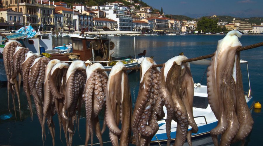
Gythion is best known as the port of ancient Sparta, a reputedly founded by Heracles and Apollo. Today it is a bustling fishing village and port town built in the Turkish tradition on the hills that surround the port.
It is at the nearby Marathonisi Islet that mythology says that Helen of Troy and her lover Paris consummated their love which sparked the Trojan Wars. There is a tower on the islet, built in the eighteenth century which houses a museum that looks at the history of the region.
There is a well preserved ancient theatre on the northern edge of the town.
Gythion is known for its seafood, and the seafood restaurants that line the port all serve traditional, fresh fare. There are some wonderful swimming beaches on either side of the town.
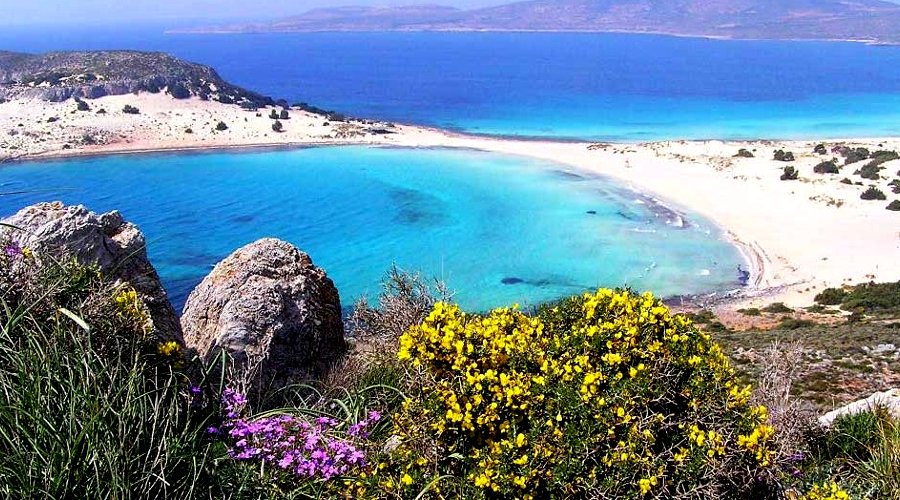
Elafonisos
Elafonisos is a small Greek island between the Peloponnese and Kythira. It lies off the coast of Cape Malea and Vatika. The area of the island is 19 square kilometres (7 square miles).
The population is between 300 and 350 during the winter but increases dramatically in the summer months. During July and August the number of tourist visitors reach over 3,000 per day (bringing with them some 1,600 cars). Many people visit the island for its light coloured, sandy beaches. Among the most well known of its beaches are Sarakiniko, Fragos (Simos) and Panagias Nissia, all filled with blue-green waters.
Elafonisos is by far the largest inhabited island in the Peloponnese archipelago, and the only one that is a separate municipality. There are also some archaeological discoveries to explore on the island and in the surrounding waters. The main church of the community is Agios Spyridon, which is built on a tiny separate piece of land which is connected by a bridge over shallow waters to the rest of the island. The community's land area also includes 3 km2 (1 sq mi) of the mainland consisting mainly of the famous Punta Beach.
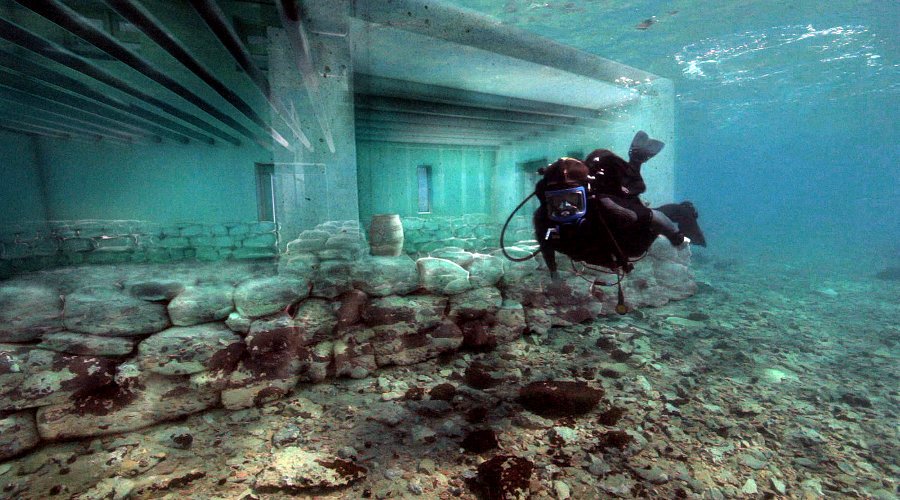
Pavlopetri
In the Peloponnese there is a small village called Pavlopetri, where a nearby ancient city dating back 5,000 years resides. However, this is not an ordinary archaeological site – the city can be found about 4 meters underwater and is believed to be the oldest known submerged city in the world.
The city is incredibly well designed with roads, two storey houses with gardens, temples, a cemetery, and a complex water management system including channels and water pipes. In the centre of the city, was a square or plaza measuring about 40x20 meters and most of the buildings have been found with up to 12 rooms inside. The design of this city surpasses the design of many cities today.
The city is so old that it existed in the period that the famed ancient Greek epic poem ‘Iliad’ was set in. Research in 2009 revealed that the site extends for about 9 acres and evidence shows that it had been inhabited prior to 2800 BC.
Scientists estimate that the city was sunk in around 1000 BC due to earthquakes that shifted the land. However, despite this and even after 5,000 years, the arrangement of the city is still clearly visible and at least 15 buildings have been found.
Historians believe that the ancient city had been a centre for commerce for the Minoan Civilization and the Mycenaean civilization. Scattered all over the place there are large storage containers made from clay, statues, everyday tools and other artefacts. The name of the city is currently unknown as well as its exact role in the ancient world.
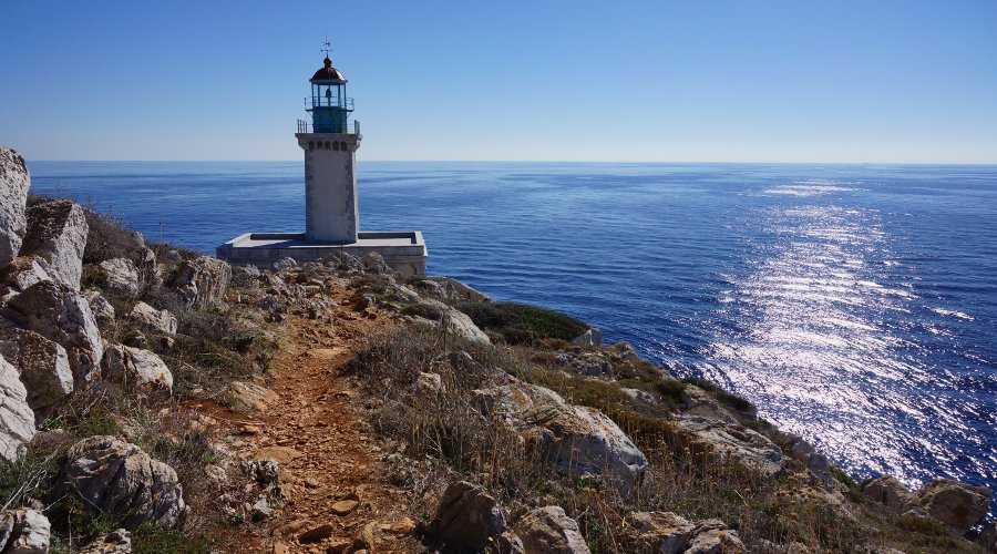
Cape Tenaro
Cape Matapan, also named as Cape Tenaro, is situated at the end of the Mani, Greece. Cape Matapan is the southernmost point of mainland Greece. It separates the Messenian Gulf in the west from the Laconian Gulf in the east.
Cape Matapan has been an important place for thousands of years. There is a cave at the tip of Cape Matapan that Greek legends claim was the home of Hades, the god of the dead. The ancient Spartans built several temples there, dedicated to various gods. On the hill situated above the cave, lie the remnants of an ancient temple dedicated to the sea god Poseidon. Under the Byzantine Empire, the temple was converted into a Christian church, and Christian rites are conducted there to this day. Cape Matapan was once the place where mercenaries waited to be employed.
More recently a lighthouse was constructed, but it is now in disuse.
As the southernmost point of the Balkan Peninsula, the cape is on the migration route of birds headed to Africa.
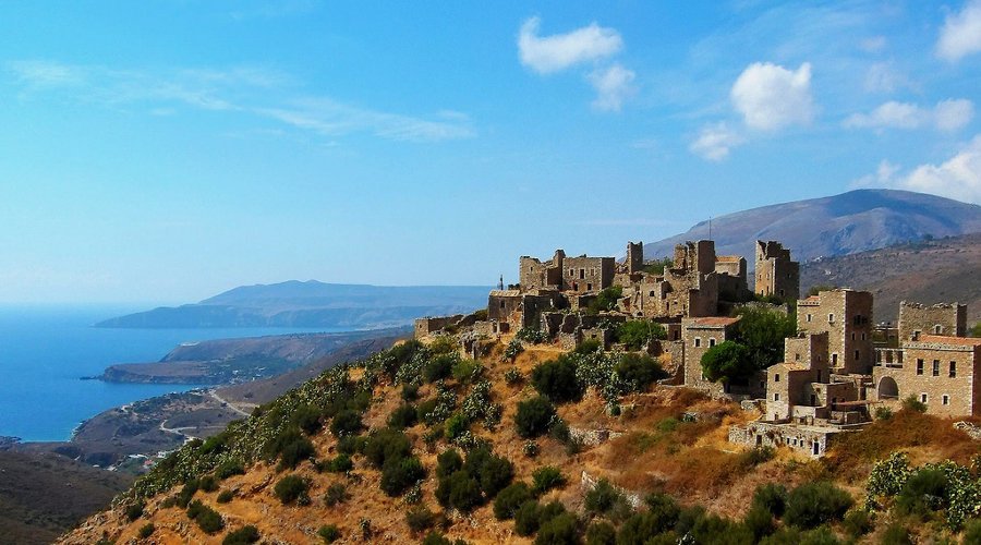
Vathia
At the heart of Laconian Mani, Vathia strongly resists the passage of time offering a journey into the past where its residents defended the prospective intruders entrenched in their imposing defensive tower houses.
Vathia is one of the most impressive traditional villages and certainly the most photographed throughout Mani.
The settlement of Vathia suddenly pops up from one of the road turns, like a citadel built on a hilltop and is just 2 km from the sea offering magnificent views to the Mediterranean.
The towers of Vathia
The entire settlement, is considered a monument of the region’s architectural heritage of the 18th and 19th centuries, during which most of Vathia’s towerhouses were built. The towers are unique examples of folk fortification around the Greece.
The known towers were made with two or three floors of stone buildings, in other parts of Mani may have more floors, which have very small characteristic windows. These were mainly used as embrasures behind which the family and defenders of the tower fought against invaders like the Turks or even pirates.
Moreover, many had machicolations from which scalding oil or water was thrown over the main door when invaders tried to breech defence. The presence of such towers build very closed, even attached, to each other was enough to create an impregnable wall of protection that in the time became the specter of any would-be conqueror.
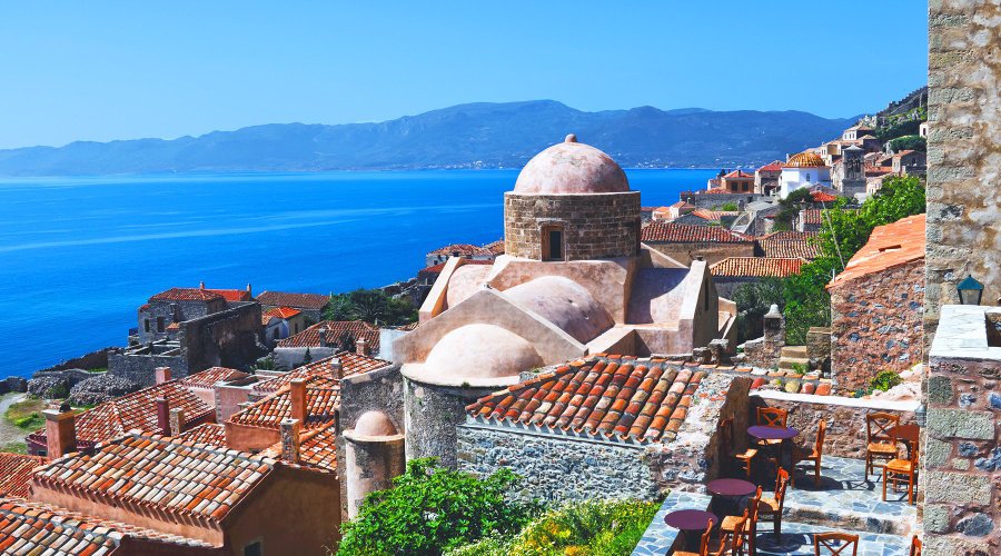
Monemvasia
Monemvasia is located in the southeastern Peloponnese in the prefecture of Laconia, 400 meters from land having been separated from the mainland by an earthquake in 375 A.D. Its name derives from two Greek words, mone and emvassi, meaning "single entrance". It was called Malmsey by old English writers, Napoli de Malvasia by the Venetians and Malvoisie by the French.
Castles, walls, old mansions, narrow cobbled lanes, churches, low arches and vaults, coats of arms, imperial marble thrones, Byzantine icons all give the impression of a town untouched by time.
It was founded by the Byzantines in the sixth century and shortly after it became an important port. It remained in Byzantine possession for almost seven hundred years until it was captured by the Franks in 1249 after a three year siege. However, it returned to Byzantine hands ten years later and became the chief port of the Despotate of Mystra.
When the rest of the region was captured by the Turks in 1460, Monemvasia remained unharmed by placing itself under the control of the papacy (1460-1464) and later under the Venetians (1464-1540). In 1540 the Turks gained control of Monemvasia after the Venetians abandoned their garrison. Although Monemvasia experienced decline under Turkish control, it underwent a revival when it returned to Venetian hands between 1690 and 1715.
In the War of Independence, Monemvasia was the first of the major Turkish fortresses to fall after a four month siege in July 1821. On August 1st 1821, overcome by misery and illness the Turks agreed to surrender to Demetrios Ypsilantis.
During World War II the New Zealand 6 Brigade numbering several thousand men was successfully evacuated on April 28th 1941 mainly from the causeway and the two piers. Soon after the Germans entered Monemvasia, which was not used as a defensive position but rather as a place for wounded soldiers to recover.
Today a causeway links the mainland town of Yefira/New Monemvasia to Monemvasia or Kastro (castle). The Kastro is divided into a lower and an upper town. Many ruins of the original 800 houses and only four out of the original forty churches can be found in the lower town. Among them is the Church of the Elkomenos Christ (Christ Dragged), which is named after a famous icon of Christ given in 1700 to the church by Andreas Likinios, philosopher and chief physician to the ruler of Moldavia, Dimitirs Kandimir. The oldest church is St. Paul’s, which was built in 956, and today houses the museum. Further on, towards the eastern edge of the lower town and closer to the sea is the whitewashed Our Lady of Hrisafittisa, which was built in the sixteenth century.
High above, castle walls protect the upper town on the summit. There one can see the remains of Byzantine houses and public buildings and a vast cistern that ensured a water supply at times of siege. A fortified zigzag path from the upper town leads to the Fortress of Goulas on the summit overlooking the town. It is entered by a tunnel that still retains its ironbound gates. Among the ruins of houses and cisterns of the acropolis of the upper town stands St. Sophia, a Byzantine church founded by Andronikos II Paleologos on a plan similar to that of Daphni in Athens.
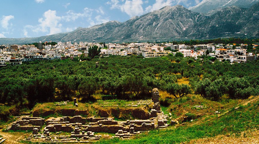
Ancient Sparta
Sparta is in the centre of the Lakonian prefecture in the Peloponnese and is one of the most famous towns in world history. Home to the Spartans, it rivalled Athens throughout ancient times only to fall into ruin. Little remains of Ancient Sparta, and the modern town, rebuilt in the 1830s in the familiar grid formation do not do justice to the town’s reputation.
Ancient Sparta was home to one of the most fearsome armies the world has known, and the city was very well known for its oppressive constitution. The modern term ‘spartan’ meaning devoid of luxuries comes from knowledge of this strict and totalitarian society. Volumes were written by the great writers of Greece on Spartan culture. Thucydides who said of Sparta:
If the city of Sparta were destroyed, and only its temples and the foundations of its buildings left, remote posterity would greatly doubt whether their power were ever equal to their renown.
Modern Spartans may have the laconic humour that gains its reputation from the region, but there is nothing to fear from the area. In the prefecture, the ancient and archaeological sites can keep enthusiasts occupied for days. The ancient theatre and the acropolis on the outskirts of the town are a fascinating as a glimpse of how Sparta used to be. The most important archaeological site is the Sanctury of Artemis Orthia, found on the road to Tripolis, another important historical site.
Sparta is a good base for exploring the Laconian prefecture. Close to Mystras and in the shadow of Mount Taygetos, Sparta has some of Greece’s more spectacular mountain scenery. Combined with the historical and archaeological aspects of the region, Sparta has much to offer the modern traveller.